Geological modeling technology is used to create a geological model based on the information collected from various surveys. We cannot actually see the geology thousands of meters underground where oil and natural gas are. Therefore, geological models are constructed to estimate the subsurface conditions and to evaluate oil and natural gas reserves based on limited information.
Over the past decade, the geological model has become more sophisticated and has evolved into the three-dimensional numerical geological model. This is represented in a computer with the information, such as subsurface structure, reservoir rock properties, and oil and natural gas distribution.
The evolution of this technology has been driven by the advance of computer technology and three-dimensional seismic surveys. And, geostatistical methods have recently contributed to create even more sophisticated geological models.
Three-dimensional numerical geological modeling technology has become crucial for planning the location of development wells and well traces, and for creating data into reservoir flow simulations in the development of oil and natural gas. In exploration as well, the trend of estimating original oil and gas in place by three-dimensional numerical geological models is now well established.
Examples of Three-dimensional Numerical Geological Model Application
A three-dimensional geological model for oil sands reservoirs
This is a sedimentary facies model integrated by the results of seismic data and well data analysis.
It can be estimated the distribution of sedimentary facies for each sequence by seismic acoustic impedance inversion and multi-attribute analysis based on the sedimentary facies at the well location
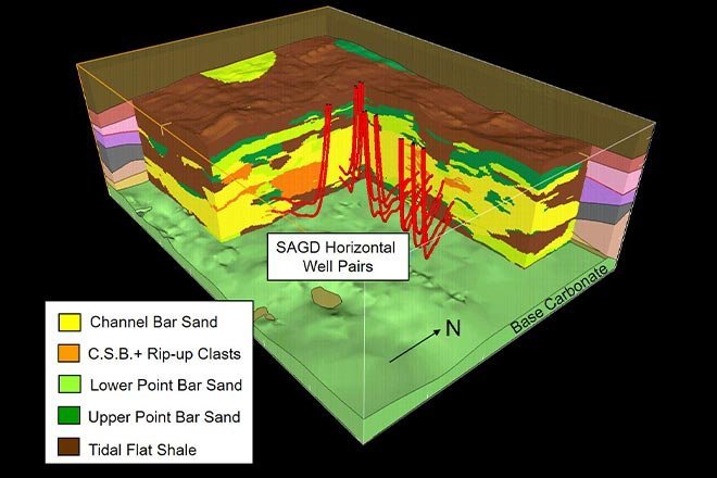
Example of a three-dimensional geological model for oil sands reservoirs (Source: *1)
High-resolution Reservoir Model by Geostatistical Method
These are reservoir models by the deterministic method (left) and the geostatistical method (right).
The fluid behavior of oil and natural gas production and injection can be simulated accurately by using the latter, higher-resolution model.
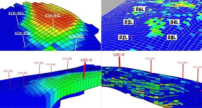
An example of three-dimensional numerical geological models of submarine fan sediment reservoir
in the Iwafune-oki oil field(Source: *2)
- Related
(Source)
*1: Akihisa Takahashi・Koji Kashihara・Shigeharu Mizohata・Nobuhito Shimada・Toru Nakayama・Masami Kose and Takahiro Torigoe, 2006, Construction of three-dimensional geological models for oil sands reservoirs in Athabasca, Canada, BUTSURI-TANSA, 59, 3, 233-244
*2: Hiroshi Yamamoto, 2008, Integrated reservoir characterization of submarine fan deposits in Iwafune-Oki Oil Field, Jour. Japan. Assoc. Petrol. Tech., 73, 6, 453-463
Our website uses cookies to improve the convenience of our visitors when browsing our site. If you agree with our policy on the use of cookies, please click the "Agree" button. If you do not agree to the use of cookies when browsing our website, please disable the cookie setting in your browser.